


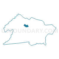
Springfield township voting district 11, Union County, New Jersey
About
Outline

Summary
| Unique Area Identifier | 622314 |
| Name | Springfield township voting district 11 |
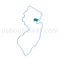
| County | Union County |
| State | New Jersey |
| Area (square miles) | 0.81 |
| Land Area (square miles) | 0.81 |
| Water Area (square miles) | 0.00 |
| % of Land Area | 100.00 |
| % of Water Area | 0.00 |
| Latitude of the Internal Point | 40.68358740 |
| Longtitude of the Internal Point | -74.32193380 |
Maps

Graphs
Select a template below for downloading or customizing gragh for Springfield township voting district 11, Union County, New Jersey


Neighbors
Neighoring Voting District (by Name) Neighboring Voting District on the Map
- Cranford township voting district 19, Union County, NJ
- Kenilworth borough voting district 1, Union County, NJ
- Mountainside borough voting district 1, Union County, NJ
- Mountainside borough voting district 9, Union County, NJ
- Springfield township voting district 10, Union County, NJ
- Springfield township voting district 12, Union County, NJ
- Springfield township voting district 13, Union County, NJ
- Springfield township voting district 9, Union County, NJ
- Union township voting district 30, Union County, NJ
- Westfield town ward 2 voting district 3, Union County, NJ
Top 10 Neighboring County Subdivision (by Population) Neighboring County Subdivision on the Map
- Union township, Union County, NJ (56,642)
- Westfield town, Union County, NJ (30,316)
- Cranford township, Union County, NJ (22,625)
- Springfield township, Union County, NJ (15,817)
- Kenilworth borough, Union County, NJ (7,914)
- Mountainside borough, Union County, NJ (6,685)
Top 10 Neighboring Place (by Population) Neighboring Place on the Map
Top 10 Neighboring Elementary School District (by Population) Neighboring Elementary School District on the Map
Top 10 Neighboring Unified School District (by Population) Neighboring Unified School District on the Map
- Union Township School District, NJ (56,642)
- Westfield Town School District, NJ (30,316)
- Cranford Township School District, NJ (22,625)
- Springfield Township School District, NJ (15,817)
- Kenilworth Borough School District, NJ (7,914)
Top 10 Neighboring State Legislative District Lower Chamber (by Population) Neighboring State Legislative District Lower Chamber on the Map
Top 10 Neighboring State Legislative District Upper Chamber (by Population) Neighboring State Legislative District Upper Chamber on the Map
Top 10 Neighboring 111th Congressional District (by Population) Neighboring 111th Congressional District on the Map
Top 10 Neighboring Census Tract (by Population) Neighboring Census Tract on the Map
- Census Tract 336, Union County, NJ (7,914)
- Census Tract 364, Union County, NJ (7,369)
- Census Tract 383, Union County, NJ (6,685)
- Census Tract 376.02, Union County, NJ (5,849)
- Census Tract 376.01, Union County, NJ (4,506)
- Census Tract 371, Union County, NJ (4,302)
- Census Tract 330, Union County, NJ (4,141)
Top 10 Neighboring 5-Digit ZIP Code Tabulation Area (by Population) Neighboring 5-Digit ZIP Code Tabulation Area on the Map
- 07083, NJ (53,053)
- 07090, NJ (30,338)
- 07016, NJ (22,625)
- 07081, NJ (15,808)
- 07033, NJ (7,914)
- 07092, NJ (6,730)